
Limerick City Council’s Riverside Projects
- This topic has 48 replies, 11 voices, and was last updated 12 years, 7 months ago by
Anonymous.
- AuthorPosts
- September 6, 2009 at 4:47 pm #710749
Anonymous
InactiveThe Council published their “Public Realm Strategy†for Limerick in October 2006. From the riverside projects, phase 1 and parts of phase 2 are now complete.
Phase 1
- Clancy’s Strand ~ Boardwalk (Treaty Stone – Curragour Bund)
- Curragour Bund ~ Mini Park / Boat Slipways
- Clancy’s Strand ~ Promenade (Curragour Bund- Sarsfield Bridge)
Phase 2
- O’Callaghan’s Strand ~ Promenade / Boat Slipway (Sarsfield Bridge – Condell Bridge)
- Steamboat Quay ~ Skateboard Park
My overall impression so far is very positive. The boardwalk is very nice to walk on, but not really nice to look at from castle side of the river. The building materials used for the promenades are top, alas some uneven surface parts on O’Callaghan Strand to be seen.
Are people happy with it so far?
Proposed Costs

Possible Timetable

- September 6, 2009 at 4:58 pm #809746Inactive
Clancy’s Strand Boardwalk – Treaty Stone

Clancy’s Strand Boardwalk – City Hall

- September 8, 2009 at 10:18 pm #809747Inactive
I didn’t know there were definite plans for the upgrading of the stretch from City Hall to Thomond Bridge. Presumably this means the ill-advised boardwalk along the front of King John’s Castle is still very much on the agenda?


- September 8, 2009 at 10:56 pm #809748Inactive
After the completion of the Clancy and O’Callaghan Strand revamps, the next riverside project to get underway was meant to have been the quayside between Sarsfield Bridge and Shannon Bridge. Clearly the recession has put paid to this for the time being.
The plans look quite good though!
“On the city-side of the river, extensive proposals for the upgrading of The Bishop’s Quay, Howley’s Quay and Harvey’s Quay, including pedestrian priority treatments, cantilevered board walks, lookout structures and high quality surfaces, lighting and street furniture, are also currently at the Part 8 Planning Stage.”
Limerick Public Realm Design Guide


- September 11, 2009 at 6:06 pm #809749Inactive
@Tuborg wrote:
I didn’t know there were definite plans for the upgrading of the stretch from City Hall to Thomond Bridge. Presumably this means the ill-advised boardwalk along the front of King John’s Castle is still very much on the agenda?
Ideas for a boardwalk along the base of the castle wall, is a nice exercise to explore.
But that’s it I hope!
Practically, the boardwalk would have to raised-up above high tide levels and thus would visually have a negative effect on the heritage value of the castle itself.
On top of that, I believe the riverfront walkway would make sense to route it’s way along Castle Lane / Castle Street so as to focus on the visitor amenities there (Museum, Castle and Bishop’s Palace).
- September 11, 2009 at 10:50 pm #809750Inactive
@CologneMike wrote:
Ideas for a boardwalk along the base of the castle wall, is a nice exercise to explore.
But that’s it I hope!
Practically, the boardwalk would have to raised-up above high tide levels and thus would visually have a negative effect on the heritage value of the castle itself.
On top of that, I believe the riverfront walkway would make sense to route it’s way along Castle Lane / Castle Street so as to focus on the visitor amenities there (Museum, Castle and Bishop’s Palace).
Yeah, if we really want to attract more visitors to our modest “medieval quarter” (hate that term btw), there isn’t much point in essentially bypassing it with a new route to the front of the castle.
It would be a different story had a quay or promenade already existed along the riverfront but it dosent and that should be the end of it. Sticking a boardwalk onto the castle would I feel, only serve to further enhance the disneyland effect, originally created by Castle Lane!:o
Incidentally, I wonder have the Council any plans to do anything more constructive with their staff car park behind City Hall?:rolleyes:
- September 12, 2009 at 9:00 pm #809751Inactive
@Tuborg wrote:
Incidentally, I wonder have the Council any plans to do anything more constructive with their staff car park behind City Hall?:rolleyes:
That’s some site!
What old remnants lie under the car park I can’t recall, but a new lane running parallel with the Alm cottages with a mix of residential / café, restaurant use would be an ideal replacement. Building materials of façades should be limestone.

Images above / below of riverside walk along city hall showing remnants at the base of the city council car park.

- September 14, 2009 at 1:11 am #809752InactiveCologneMike wrote:That’s some site!
What old remnants lie under the car park I can’t recall, but a new lane running parallel with the Alm cottages with a mix of residential / café, restaurant use would be an ideal replacement. Building materials of façades should be limestone.
The site under the car park is one of the best kept secrets in Limerick, a complete medieval undercroft/cellar was discovered there during the construction of the city hall, the two blocked doorways lead directly into a barrel vaulted cellar 20 m long ,7 m wide,with a range five arched bays separated by a central arched wall, the building dates to the 13th century and is contemporary to the castle ,the wicker centering and arched bays were inserted in the late medieval period.
I’ve been inside on a few occasions and its very impressive, the corporation literally don’t know what to do with it, there were plans to open the cellar as a riverside amenity but its just forgotten, it’s my pet project to have it opened and properly appreciated. - September 14, 2009 at 8:35 pm #809753Inactive
Nice sketch, I remember having a glimpse into it a few years back before they blocked it up.
@Junior wrote:
. . . . . . . . the corporation literally don’t know what to do with it, there were plans to open the cellar as a riverside amenity but its just forgotten, . . . . . .
Maybe it was a good thing that they “moth-balled†it till the time is ripe to properly take it a stage further.
How would you like to see it been used yourself?
Going from the colour scheme (pink) in the map above then this area should be the next phase in line (along with the quays) to be rolled out.
Instead of running a boardwalk along the base of the castle, I think they would be better diverting that money towards a fund for opening that medieval undercroft/cellar.

Above is a view of the steps descending to the river between King John’s Castle and Thomond Bridge. If I’m right, then one can see that the tide comes up as far as the fourth step in this image. Therefore one gets a fair idea of the height required to run the boardwalk. Controversial!!!
By the way it would be nice if the council could repair the cavity 🙁 on the right with an appropriate block of limestone, as the saying goes a stitch in time saves nine!

Below: Optional proposals for provision of pedestrian link around the base of the Castle.
- September 15, 2009 at 12:47 am #809754Inactive
@Junior wrote:
@CologneMike wrote:
That’s some site!
What old remnants lie under the car park I can’t recall, but a new lane running parallel with the Alm cottages with a mix of residential / café, restaurant use would be an ideal replacement. Building materials of façades should be limestone.
The site under the car park is one of the best kept secrets in Limerick, a complete medieval undercroft/cellar was discovered there during the construction of the city hall, the two blocked doorways lead directly into a barrel vaulted cellar 20 m long ,7 m wide,with a range five arched bays separated by a central arched wall, the building dates to the 13th century and is contemporary to the castle ,the wicker centering and arched bays were inserted in the late medieval period.
I’ve been inside on a few occasions and its very impressive, the corporation literally don’t know what to do with it, there were plans to open the cellar as a riverside amenity but its just forgotten, it’s my pet project to have it opened and properly appreciated.Interesting posts.
In a way it’s good that it’s being mothballed, imo.
Ideally a team of experts would make a complete survey of the “Medieval Quarter” and then draw up a development plan to on how best to restore some integrity to the area. It wouldn’t have to be done all at once but a series of projects running for the foreseeable future should be started. Something like Limerick Civic Trust only solely focussed on the Medieval Quarter.
Developing it in a piecemeal fashion could easily lead to a disjointed development.
- September 15, 2009 at 3:26 pm #809755Inactive
@justnotbothered wrote:
Interesting posts.
Indeed interesting projects! Limerick City Council Links . . .
Limerick Public Realm Design Guide
Limerick City Centre Remodelling and Pedestrianisation (O’Callaghan Strand and Curragour Plans)
Mayor of Limerick opens €2.1 million Clancy’s Strand restoration project
@justnotbothered wrote:
Ideally a team of experts would make a complete survey of the “Medieval Quarter” and then draw up a development plan to on how best to restore some integrity to the area. It wouldn’t have to be done all at once but a series of projects running for the foreseeable future should be started. Something like Limerick Civic Trust only solely focussed on the Medieval Quarter.
Denis Leonard (Limerick Civic Trust) expressed similar sentiments a while back where he said that a priority would be to appoint a heritage and a conservation officer.
“Most other cities have heritage and conservation officers – the Heritage Council of Ireland pays 50 per cent of their salaries – Limerick City Council must be urged to make these appointments.
Did anything come out of it?
By the way have you seen the new Clancy Strand Boardwalk where parts of the railing are covered with sheets of plywood. :confused: Any idea what the storey is behind that?
- September 15, 2009 at 5:18 pm #809756Inactive
The most puzzling thing about the designation of ‘Medieval Quarter’ is that not only does it exclude Irishtown,thereby diminishing its historical significance but on King’s Island the northern section of the medieval town from Castle St. northwards is also cut off.
The Bishop’s Palace, the home of the Limerick Civic Trust probably contains quite a bit of medieval fabric,especially in the basement.It was the site of Striches Castle prior to its remodeling as a Palladian structure.
On Verdant Place along the Shannon north of Thomond Bridge there is a fine stretch of the medieval town wall complete with the remains of two round mural towers.
I think this is a pointless omission from the medieval quarter, it seems that the council is solely concentrating on King John’s Castle and St.Mary’s Cathedral and not realising the possible economic and tourism potential literally on their doorstep.The plywood boards on the Clancy’s Strand boardwalk have thankfully been removed.
- September 17, 2009 at 9:21 pm #809757Inactive
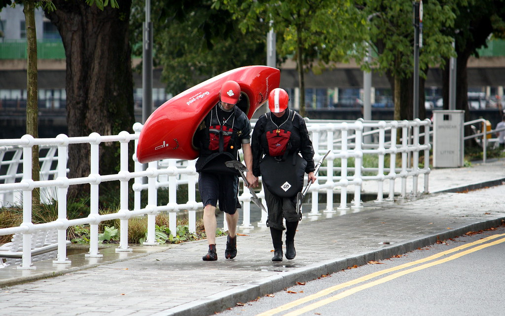
Clancy’s Strand ~ Curragour Bund
The river has been for years a very under utilised resource. Much so its nice to see this bund been used for water sport! 😎 When the tide falls, coupled with a spring flood and the ESB releases water at Ardnacrusha. Then the conditions are ideal for the kayakers to hit the falls!

Kayaking image above from this years “National Championships and Team Selection†from paddleforfun.
See also: Adrian Shanahan, Playak, Limerick Canoe Club
Image from last years completed park. It has both pedestrian and limited vehicular access (boat slipways). The entrances can be closed for high spring tides.
Drawing of the Curragour Bund.
- February 24, 2010 at 12:15 pm #809758Inactive
June Deadline for City’s Docker Monument (Limerick Independent)
A MONUMENT to honour the contribution of Limerick’s dockworkers is expected to be erected over the coming months and officially unveiled in June, writes Rachael Finucane. The work will consist of two life-sized dockers carrying a plank and will be at Spokane Walk between Bishop’s and Honan’s Quays. The design—by Limerick-born artist, Michael Duhan—was significantly scaled down from four figures to two and will cost €63,000 as opposed to the original €92,000 estimate.
At a meeting of the arts, culture and sports SPC this Monday, arts officer, said: “We had our first meeting at the site with the artist as well as two officials from the Transport and Infrastructure Department and Cllr Jim Long. The two figures will be in front of the old ESB building, near the river. We hope to have it in place by June.†Cllr Long welcomed the long-awaited monument and said that original cobblestones taken up in the redevelopment of the dockland area will be incorporated into the memorial.
“We have collected over 360 dockers’ names and are in discussions with a local printer to produce a booklet on the history of the docks. This monument is four or five years in the making and I’m looking forward to this commemoration of the working class people of Limerick.â€
Is this work for the monument in tandem with the planned boardwalk for the quays?
See timetable and costs for phase 3 at the top of the page.
See also similar monument / location from Dublin.
- February 24, 2010 at 3:31 pm #809759Inactive
I wonder were those projects costed during a different economic climate? 😀
€7.5 million for the quayside between Shannon and Sarsfield Bridges? You would think that significant savings could be achieved now! This stretch is in really dire need of attention, the pavements and road surface are crumbling and the riverside railings look like they’re going to fall into the Shannon fairly soon!
I’ve no idea what the situation regarding funding is though. The latest is that they hope to get started on William Street this Summer although there has been so many false starts on that front, I wouldn’t be getting my hopes up!
I wonder will the limited funding thats currently available be reserved for city centre re-modelling, thus leaving the remaining riverside projects on the long finger?
- February 27, 2010 at 2:03 pm #809760Inactive
@Tuborg wrote:
I wonder were those projects costed during a different economic climate? 😀
€7.5 million for the quayside between Shannon and Sarsfield Bridges? You would think that significant savings could be achieved now! This stretch is in really dire need of attention, the pavements and road surface are crumbling and the riverside railings look like they’re going to fall into the Shannon fairly soon!
Looking at the figures and the coloured time schedule for phase 3, they reveal some conflicting facts. :confused: For one, Honan’s Quay is on the Arthur’s Quay side of the bridge. Technically they are 4 quays between the two bridges (i.e. Harvey’s, Howley’s, Bishop’s and Russell’s), but I suppose they are referring to the whole stretch as Harvey’s Quay? Also coloured are Lower Shannon and Cecil Streets. The Boardwalk itself resembles bridging segments thus more expensive?
I’ve no idea what the situation regarding funding is though.
That’s the big bord snip question! The private sector played their part on the redevelopment of the riverfront, so the city council / department of finance must fulfil theirs. This investment would repay economic dividends for the city as it would attract locals and visitors to the whole riverfront.
- February 27, 2010 at 2:16 pm #809761Inactive
O’Callaghan Strand
The O’Callaghan Strand promenade looks very well from Sarsfield’s Bridge down as far the slipway (St. Michael’s Rowing Club). It’s now a very nice stroll from Thomond Bridge to Condell Bridge. 😎
Two issues here:
On O’Callaghan Strand, the council has created a riverside promenade protected by maritime-style railings along the Shannon’s north bank. But the design by Nicholas de Jong, who seems to have done most of Limerick’s new public spaces, is marred by tubular railings to the rear that seem quite superfluous
Irish Times ~ Frank McDonald May 2009
Secondly, sadly there is some very poor finishing on a part of it where the pavement merges with the limestone quay. The crooked line here is not an aesthetic sight and an uneven surface is prone to cause personal injuries. I would love to know the city official who signed this work off as acceptable. See image below.
- March 3, 2010 at 10:17 pm #809762Inactive
@CologneMike wrote:
Looking at the figures and the coloured time schedule for phase 3, they reveal some conflicting facts. :confused: For one, Honan’s Quay is on the Arthur’s Quay side of the bridge. Technically they are 4 quays between the two bridges (i.e. Harvey’s, Howley’s, Bishop’s and Russell’s), but I suppose they are referring to the whole stretch as Harvey’s Quay? Also coloured are Lower Shannon and Cecil Streets. The Boardwalk itself resembles bridging segments thus more expensive?
That’s the big bord snip question! The private sector played their part on the redevelopment of the riverfront, so the city council / department of finance must fulfil theirs. This investment would repay economic dividends for the city as it would attract locals and visitors to the whole riverfront.
I’d actually forgotten about the boardwalk even though it was I who posted the plans for it a few months back! 😮 It would definitely add quite a bit to the cost of the overall project alright!
It’s not totally clear from the renders that have been released so far but it looks like the proposed boardwalk will run from Poor Man’s Kilkee to in or around the slipway/steps on Howley’s Quay. The quayside is wider from this point on towards Shannon Bridge so I don’t think that a boardwalk is needed here anyway. Although maybe a boardwalk could be considered from Poor Man’s Kilkee to Sarsfield Bridge?
Unfortunately those quays are virtually deserted at the moment. Off the top of my head I can only think of 2 businesses that are operating at the moment. The vacant ESB site, Henry Street Garda station, the former Sarsfield Bridge hotel and adjacent apartment block all need to be redeveloped if we are to eventually entice new businesses like cafes, restaurants etc to open up and bring some vibrancy to the riverfront.
Of course there is also the question of what to do with the Boat Club. This site has a key part to play in the redevelopment of the city quays!
Proposed Boardwalk

- March 7, 2010 at 6:13 pm #809763Inactive
Skatepark ~ Steamboat Quay
The Skatepark seems to be a big hit since it opened in summer 2008.
According to the Council it costed around €300,000 to construct, which seems to me to be good value for money.
Image by dropsideeazy
- March 11, 2010 at 5:21 am #809764Inactive
Nice to know about the project. Boat club is the wonderful place where a person can join together and can have a great fun. Having a boat club will have so many advantages as so many people to like to join in a boat club to have a nice time. Many people join boat clubs because there are persons with the same interests where every one can share there own views about boating.
- March 13, 2010 at 5:04 pm #809765Inactive
Skyfest comes to Limerick tonight (Limerick Leader)
Saturday 13th March
The National Lottery sponsored firework spectacular ‘Skyfest’ will feature 1.5 tonnes of fireworks launched over Limerick city on Saturday evening, with up to 50,000 people expected to line the banks of the River Shannon to watch the proceedings.
Hmmm . . . . . . . . that should provide an interesting “stress test†for the new board walk?
Here just some superb images of the firework spectacle.
- March 14, 2010 at 5:01 pm #809766Inactive
Arthur’s Quay Park 1991 (Murray Ó Laoire Architects)
MOLA were commissioned in 1986 by Limerick Corporation to instigate a riverside study which sought to give a physical and strategic context to impending incentives legislation for Limerick.
This framework plan allowed Limerick Corporation (in association with Shannon Development Co.) to identify a number of amenity and non commercial projects related to the development of tourism infrastructure such as the new Tourist Information and Civic Park. The Park was reclaimed and a new quay front walkway constructed along with performances spaces and planted areas.
As part of the regeneration of Arthur’s Quay Park, a new landmark Tourist facility was constructed at the entrance to the park. The brief included a covered outdoor meeting area. Both functions are combined in a suspension structure signalling the entrance to the park.
The programme from brief to completion was 10 months, and building itself was completed on site in 8 weeks.
The project has received substantial recognition through national and international awards and publications including the prestigious R.I.A.I’s Triennial Gold Medal for Architecture in 1995.
The street railings were removed two years ago . . . . . . . an unusual measure to improve public safety.
- March 22, 2010 at 3:35 pm #809767Inactive
@CologneMike wrote:
The street railings were removed two years ago . . . . . . . an unusual measure to improve public safety.
Lack of passive surveillance saw an end to the railings.
The park is much safer with them gone. - April 2, 2010 at 11:26 am #809768Inactive
Never mind the boardwalks.
Look at the Thompson proposal for the river amenities –
Isn’t the idea of converting the drydock to a lido brilliant ?
- April 10, 2010 at 10:05 pm #809769Inactive
@teak wrote:
Look at the Thompson proposal for the river amenities
Urban Beach
A very short bathing season June to September with Irish weather permitting. A glass dome urban beach all year round would be a great asset. Though the cut-stone dry dock is worth preserving.Lookout Bridge
A practical solution at a dangerous road crossing point. The skateboard scene will like it too. It was a pity that the resources were not there in the late eighties to build a suspension bridge in the first place i.e. instead of from riverbank to riverbank but suspending it from the height of Henry Street to the other side thus giving the Dock Road / O’Callaghan’s Strand enough clearance to drive / walk under it.People’s Piers
It would clutter up the river in my opinion, if people want to get closer to the river then get in a boat.Weir Walk
Nice idea, piggy-backing along the weir. Though I would fear it could blot out the view of the Abbey River from the Clancy’s Strand side? - April 11, 2010 at 12:35 pm #809770Inactive
Though the cut-stone dry dock is worth preserving.
What do you mean ?
All of the cut stone or just the part at ground level ?
If it’s to be an open air pool, then it can only be so deep for water-safety reasons.
This makes it necessary to build up the lower levels of the drydock, after filling and draining pipes are lain.
Would also need to be lined (insulation + sealing) and painted azure for better appearance.
Personally I’d say the additional amenity of such an amenity would be well worth the loss of a piece of the urbs antiqua big limestones . . . - April 11, 2010 at 8:41 pm #809771Inactive
@teak wrote:
Though the cut-stone dry dock is worth preserving.
What do you mean? All of the cut stone or just the part at ground level ?
I meant the whole structure. If the docks were ever to be redeveloped, then the dry dock could be become part of a maritime heritage museum. There is plenty of space to develop an “Urban Beach†behind the Clarion Hotel / Hegarty’s scrap heap. Digging a hole is no big problem.
If it’s to be an open air pool, then it can only be so deep for water-safety reasons.
This makes it necessary to build up the lower levels of the drydock, after filling and draining pipes are lain.The higher the diving boards, the deeper the pool?
Would also need to be lined (insulation + sealing) and painted azure for better appearance.
Well sealed I hope, the old gas works across the road is only yards away and is classed a “Seveso site†😡
Personally I’d say the additional amenity of such an amenity would be well worth the loss of a piece of the urbs antiqua big limestones . . .
We can have both.
See also similar drawing from thread “Graving docks at Grand Canal Dockâ€
Photos LimerickStudent and Limerick Museum
Update: Found the third image on the Limerick Museum site today, gives a good working close up of it.Paddle steamer The Flying Huntsman, Limerick, in dry dock propped with spars.
See larger image.
- April 13, 2010 at 1:23 pm #809772Inactive
the dry dock could be become part of a maritime heritage museum.
That part of the docks (and that is all that the LCC may ever be able to get from the Port Company) is not so big as to be able to facilitate 2 major complexes.
As well as the open air pool, one would need decently arranged changing rooms, warm salts rescue paths, unobstructed access for emergency vehicles regardless of crowds, etc.If it went to a choice for that site, I think that the more important amenity would be the pool.
But if the museum can only be sited there, then where does one put the open air pool ?All academic anyway as the local council has no money !;)
- June 2, 2010 at 11:57 pm #809773Inactive

Public Realm Phase 3 ~ Harvey’s Quay
I saw on boards.ie that the paving stones along the quays are been taken up. Are they been replaced or just getting re-laid? The type of cobble stone used in the last photo below is definitely more preferable than those in the first image.
I suppose the fact the railings were only re-painted white, would mean the original plans as in the drawings above for phase 3 of the quays (Harvey’s, Howley’s, Bishop’s and Russell’s) are not now going ahead?
Images from Stan the man
- June 3, 2010 at 11:51 pm #809774Inactive
@CologneMike wrote:
Public Realm Phase 3 ~ Harvey’s Quay
I saw on boards.ie that the paving stones along the quays are been taken up. Are they been replaced or just getting re-laid? The type of cobble stone used in the last photo below is definitely more preferable than those in the first image.
I suppose the fact the railings were only re-painted white, would mean the original plans as in the drawings above for phase 3 of the quays (Harvey’s, Howley’s, Bishop’s and Russell’s) are not now going ahead?
Looks to be the same concrete setts that they used for the footpaths along the new link road on Upper William Street/Sexton Street and the new bus lane on Mulgrave Street. Maybe they just wanted to use up some left overs.
I haven’t been down that way in a good while but the paving was in fairly poor shape. Perhaps this is just a stop-gap measure until the money hopefully becomes available to revamp the quayside as envisaged in the plans above.
- June 4, 2010 at 1:18 pm #809775Inactive
@CologneMike wrote:
Public Realm Phase 3 ~ Harvey’s Quay
I saw on boards.ie that the paving stones along the quays are been taken up. Are they been replaced or just getting re-laid? The type of cobble stone used in the last photo below is definitely more preferable than those in the first image.
I suppose the fact the railings were only re-painted white, would mean the original plans as in the drawings above for phase 3 of the quays (Harvey’s, Howley’s, Bishop’s and Russell’s) are not now going ahead?
Images from Stan the man
This is in fact going to be where the Dockers Memorial will be unveiled in a few weeks.
- June 4, 2010 at 4:38 pm #809776Inactive
@PoxyShamrock wrote:
This is in fact going to be where the Dockers Memorial will be unveiled in a few weeks.
I should re-read my posts sometimes! 😮
Thanks PoxyShamrock, see February post!
The work will consist of two life-sized dockers carrying a plank and will be at Spokane Walk between Bishop’s and Honan’s Quays.We hope to have it in place by June.†Cllr Long welcomed the long-awaited monument and said that original cobblestones taken up in the redevelopment of the dockland area will be incorporated into the memorial.@Tuborg wrote:
Perhaps this is just a stop-gap measure until the money hopefully becomes available to revamp the quayside as envisaged in the plans above.
I thought the same and I really hope the council can get the funds to finish the quays off properly.
- June 4, 2010 at 11:56 pm #809777Inactive
The â€Managers Report Draft Budget 2010†for the Limerick City Council reveals the following status for the quays.
Transportation and Infrastructure ~ Roads and Water Services
3. Road Maintenance
In 2009 Limerick City Council carried out in excess of 100,000m² road surface overlay and strengthening works at various locations throughout the city including major resurfacing works at;. . . . . . . . . . . . Howleys Quay, Harveys Quay . . . . . . . .
6. Riverside Strategy
The Riverside is one of the most important natural assets of Limerick City and this is recognisable by the substantial new development investment currently taking place along the riverside. To complement these initiatives by the private sector Limerick City Council has prepared a riverside strategy that aims to re-evaluate the potential of this important public area to create a high quality amenity area that compliments and reinforces the Riverside City image. In this respect several schemes are currently being advanced and these include.d) Other Riverside Projects
Plans are currently being developed for other schemes along the riverside including:Full upgrade of the riverside promenade between Shannon Bridge and Sarsfield Bridge along Bishop’s Quay, Howley’s Quay and Harvey’s Quay.
So the road on the quays got resurfaced in 2009 and the promenade (Public Realm Phase 3) is still in planning.
- June 5, 2010 at 3:27 pm #809778Inactive
Just a pity that the memorial isn’t being unveiled in a fully refurbished quayside setting instead of the current ragged surroundings.
I found some model images of the memorial. It was originally meant to consist of four bronze figures but sadly it’s been scaled back to just two (the lads carrying the plank of wood). Maybe they might commission the rest of the figures when the money becomes available.


- July 6, 2010 at 2:55 pm #809779Inactive
Commemorative Booklet published to mark the unveiling of the Docker’s monument.


Images from CCSL
More photos of the sculpture here.
- September 23, 2010 at 9:32 pm #809780Inactive
Marie Hobbins writes in this week’s Limerick Post where Vincent Murray (City Council Senior Engineer) discloses details for Boardwalks.
. . . . . . . . It was also revealed that the council is hoping of funding being confirmed by February.“Boardwalks will be built from Poor Man’s Kilkee to Lower Cecil Street – we could start this in October. . . . . . . . “
- September 24, 2010 at 2:38 am #809781Inactive
i think Vincent Murray means October 2011 when he says that. The quote is not clear but it is most likely what he means.
- September 27, 2010 at 3:28 am #809782Inactive
New riverside project in King’s Island district
Written by Marie Hobbins
FRIDAY, 24 SEPTEMBER 2010 08:49
TENDERS are likely to be sought for the development of a new Island Bank Walkway in King’s Island.
The project will include an upgrading of the existing surface along the route with new tarmacadam or patch repairs to the existing tarmacadam, surfacing, as appropriate, the installation of kerbs, fencing and landscaping works.Some funding is available from the regeneration programme, and Cllr Gerry McLoughlin has submitted a notice of motion to Limerick City Council that it puts in place an environmental plan for the project, “for the benefit of the wider area and for regional tourism”.
The redevelopment plan for the bank walkway includes the installation of pedestrian turnstile access points for seven locations including King’s Island Community Centre, Athlunkard Street and Lee Estate.“It is also proposed to provide a new tarmacadam surface access between the Abbey River and Lee Estate, suitable for occasional vehicular access, with speed ramps and vehicular gates – essential for the emergency services,” said Cllr McLoughlin, who added:
“There will also be a line marked out for cyclists, as well as turnstiles to block out entry to cars and quad bikes. A boardwalk will link up with King John’s Castle – it will be for the local people, but also for everyone in the city, as well as visitors”.Describing the project as “an ambitious plan,” Cllr John Gilligan, a resident of King’s Island, said the bank had began to sink – I totally support this project getting underway”.
Cllr Tom Shortt said be believes the Island Bank was built by direct labour during the famine years.
“As it stands today, it is seriously under-utilised but it is a lovely walk and I support the project one hundred per cent – it is another great example of turning the city towards the river.”Cllr Shortt, who resides on Brown’s Quay, is calling for the removal of the salmon weir on the river. The weir is located in the stretch of river that flows between the island of St Mary’s Park and the Thomondgate area.
“It ceased operation 30 years ago and is now a derelict site in the river and is obstructing navigation. The Fisheries Board should now remove it – to do so, would give a new lease of life to the development of the river”.Cllr Orla McLoughlin said that the weir was shrouding St Mary’s Park.
“We sing the parish anthem – There is an Isle, which means so much to us – the creation of the new Island Walkway presents an opportunity to rectify the imbalance of development in King’s Island”. - September 27, 2010 at 12:11 pm #809783Inactive
Not sure what Orla McLoughlin means when she says the weir is shrouding St. Mary’s Park, but it’s quite difficult even for small rowing boats to get through it, and I remember one particularly incident for five young oarsmen a few years ago when their boat was snapped in two as it was forced sideways through the weir by a going tide. They had a lucky escape that day. The weir served only one purpose and that was to exploit the natural salmon stocks in the river, and it did so to near-extinction. Time for it to go. I would imagine it would cost a huge amount to remove it though.
- September 27, 2010 at 10:10 pm #809784Inactive
@justnotbothered wrote:
New riverside project in King’s Island district
TENDERS are likely to be sought for the development of a new Island Bank Walkway in King’s Island.
. . . . . Cllr McLoughlin, who added:
“There will also be a line marked out for cyclists, as well as turnstiles to block out entry to cars and quad bikes. A boardwalk will link up with King John’s Castle – it will be for the local people, but also for everyone in the city, as well as visitorsâ€. . . . . . .This old image shows that the road from the Island field (Verdant Place) had originally no direct access to the bridge via the Toll House, as it seems that there was a flight of steps at that junction?
I wonder are these steps still there under the road? Maybe instead of a boardwalk link with the castle why not extend a pedestrianised river walk around the rear of St.Munchin’s Church by restoring the former steps? The junction as it is today, is definitely not the best location for road safety reasons. Access to St. Mary’s Park is now better served at the roundabout 200 yards further on?
Limerick Museum: Larger image
- September 29, 2010 at 10:47 pm #809785Inactive
Damaged Railings ~ Curragour Bund (PDF)
- SUPPLIER: Burdens Ltd. Little Island, Co. Cork
- REF: BXPU 1577-5-BP
- MATERIAL/FINISH/COLOUR: Duracast polyurethane, colour: white
- SPECIAL FEATURES: 75mm dia. Stainless steel top rail
- METHOD OF FIXING: As suppliers instructions
Looking at the second railing bar from the bottom, one can only speculate that these bars are either too soft or the wrong diameter size was used as they don’t live up to any anti-vandal expectation.
The missing one was only half hanging-off two months ago and to my surprise the hollow railing bar had two / three thick cable-wires running through them. Why?
What’s the storey here then? Damage by vandalism, soft materials or reversing boat-trailers? 🙁
See also Broxap 1577-5 Quayside Curved or PDF
- September 29, 2010 at 11:36 pm #809786Inactive
Good questions, Mike. I would suspect vandalism/ill suited materials as i don’t think I’ve seen any boat trailers use that slipway, the kayakers usually park by the Curragower bar from what I’ve seen.
If you were to stand on the bars would they bend (ie, weak material) or what type of effort would be needed to damage them in this instance?
- October 28, 2011 at 4:56 pm #809787Inactive
Funding secured for new riverside trail in Limerick city

By Owen Hickey (Limerick Leader)
LIMERICK’S tourism industry is set for a major boost after funding of over €3m was secured for the development of a trail along Howley’s Quay.
The trail, which covers the area between Shannon Bridge and Sarsfield Bridge, is the next stage of the Limerick Riverside Improvement Strategy. One side of the river bank is set for major remodelling in the new project with public realm works, including coach parking bays, interpretation boards, board walks, street furniture and lighting and slipways to the river.
The funding is being provided by Fáilte Ireland under the Tourism Capital Investment Programme.
Minister for Finance Michael Noonan believes this is a critical development for the city and thinks locals will benefit.
“I welcome this allocation by Fáilte Ireland towards the development of Limerick’s public tourism infrastructure. The works on the banks of the river Shannon are critical to further developing Limerick’s position as a Riverside City and this funding will assist in developing the surrounding city as an attraction for visitors,” he said.
This is good news!
- October 28, 2011 at 11:02 pm #809788Inactive
Sounds good. The work done to the two Strands was very well done so I’d imagine if it’s more of the same it can only be a good thing.
- January 15, 2012 at 7:07 pm #809789Inactive

@Dan S wrote:
. . . . . . The main focus of this project was the riverfront from the Hunt museum to the castle. I’ve put it all online including the panels I showed at the library with all the explanatory notes. It can be viewed here http://www.townscaper.com/
Museum Plaza
Sarsfield Hse. In its current form does not contribute to the spatial coherence of the site. It sits in space in an obstructive way when it ought to be helping to positively shape the spaces around it. Thus The Custom House Park, (the space behind the Hunt Museum), does not have a strong sense of enclosure or sense of place (which a strong sense of enclosure can bring).Creating an active frontage along its length is one part of the solution.
Another is to adjust the heigtht of the new building to match that of the Hunt Museum, continuing the cornice line. This would help create a more evenly balanced and unifed spatial boundary, and thus a greater sense of enclosure and spatial cohesion.
I like your ideas for a museum plaza.
Your “before and after” comparison of the frontage of Sarsfield House along the Custom House Quay really sends the message home as to how much potential the riverfront has.
- May 22, 2012 at 11:50 am #809790Inactive
Lots of activity on Harveys Quay area yesterday. Are they finally starting the new boardwalks? Can’t see anything in the Leader or City Council websites.
- November 30, 2012 at 10:08 pm #809791Inactive
City Quays – Limerick Riverside Improvement Strategy (City Council)
Funded under the NDP (2007 – 2013) Tourism Programme and by Limerick City Council
The City Quay’s project represents the next stage in the City Riverside Improvement Strategy, which aims to provide a high quality waterside environment for public use and enjoyment of the River Shannon, as well as a unique setting for the on-going revitalisation of the city centre.
The project is being undertaken by Limerick Council at a total cost of almost €5 million, with part-funding secured through Shannon Development and Fáilte Ireland under the NDP (2007–2013) Tourism Programme.
The River Shannon is one of the most important assets of the city, providing a unique natural resource for both residents and visitors, and as recognised by substantial new development investment and the overall vision for Riverside City.
This stage of the strategy will see substantial upgrading of the waterfront between Shannon Bridge and Sarsfield Street, comprising widened and resurfaced footpaths in high quality materials, boardwalks extending out over the river, a distinctive viewing/performance structure, new street furniture and improved street lighting, seating areas and landscaping.
The project will reinforce the recently completed improvement works on O’Callaghan’s and Clancy’s Strands through the realisation of a continuous visitor trail around the key sections of the river with enhanced water-based activities, while also complementing the public realm improvements of the City Centre.
The construction contract for the quays has been awarded to L&M Keating, Kilmihill, with a contract period of 7 months. The scheme design has been prepared by Nicholas de Jong Associates (Urban Design), with O’Shea Consulting (Engineers) and Lawlor & Partners (Project Management).
Development of the design proposals has entailed on-going consultation with key stakeholders and local businesses, which will continue throughout the construction programme.
- January 30, 2013 at 9:07 pm #809792Inactive
Has anybody any updates of this project? I’m looking forward to sitting outside Claw’s with a pint in the sunshine looking at the swans.
- May 12, 2013 at 10:57 pm #809793Inactive
City Quays upgrade May 2013
The remodelling of the quays from Shannon bridge to Sarsfield bridge is progressing. The stretch from Sarsfield bridge to Poor Mans Kilkee would appear to be the most advanced. A section of the quayside from Lower Cecil Street to Lower Shannon Street is to be pedestrianised as part of the project although there are no visible signs of this yet.
The boardwalk and new lighting scheme will obviously not be installed until the final stages of the scheme.
Thankfully the paving material being laid appears to be of a higher standard than was used in recent years on William Street and Sarsfield Street. Which it would seem are not entirely suited to an Irish climate given the extent of the weathering and discolouration.
A similar issue would also appear to be arising here just as it did on the revamp of the quays on the opposite bank. The integration of the new paving with the existing quay wall will be problematic again. We’re going to see some pretty odd angles at the tie-in points but I think it’s entirely appropriate that the quay wall is preserved rather than covered over.


- AuthorPosts


- You must be logged in to reply to this topic.